Drones for crop scouting have moved well beyond the “interesting technology to watch” stage, they’re now a practical, proven part of how modern UK farms are managed. What started as a niche option for large agricultural operations is now accessible to farms of all sizes, and the results speak for themselves. From spotting a disease patch before it spreads to monitoring the effects of a dry spell across a large field, aerial scouting is giving farmers a level of visibility that simply wasn’t possible before.
Using drones for crop scouting is something we’ve been doing at Thames Valley Drones since 2017. That’s years of working directly with farmers through real growing seasons, helping them catch problems early, reduce unnecessary inputs, and make more confident decisions about what’s happening across their land. BBC Radio 4’s Farming Today recently highlighted the growing role of drones and AI in agriculture, framing it as an emerging shift. For many of the farmers we work with, that shift has already happened.
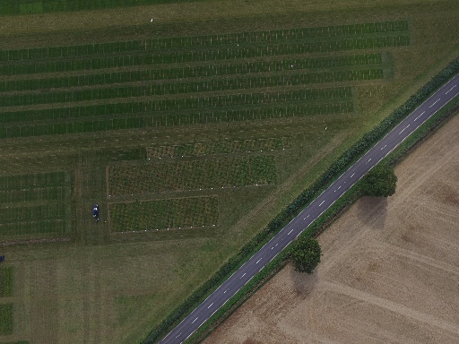
Crop scouting is the regular inspection of fields to assess crop health, identify pests or diseases, and track how growth is progressing at different stages of the season. Traditionally, it means walking fields or driving through them on a tractor, effective in its way, but slow, labour-intensive, and limited by what you can actually see from ground level. A drone changes that entirely. Large areas can be surveyed from the air in minutes, giving you a comprehensive picture of what’s happening across the whole field rather than just the parts you happened to walk past.
High-resolution imagery from above gives you a complete view of your fields in a single flight. Uneven crop growth, waterlogged areas, drought stress, and soil variability all show up clearly from the air in ways that are much harder to spot, or easy to miss entirely, at ground level. With the right mapping software, those images are stitched into detailed field maps you can return to throughout the season, building up a picture of how different areas of your land perform over time.
Multispectral and thermal cameras can identify issues before they’re visible to the naked eye. Nutrient deficiencies, early-stage crop disease, and pest pressure often show up in the data well before you’d notice anything walking the field. Catching problems at that stage means targeted, timely intervention rather than blanket treatment, which reduces input costs and limits unnecessary chemical use. That matters both for the bottom line and for the land itself.
Drone data doesn’t sit in isolation. It feeds directly into farm management systems to support precision agriculture practices, variable rate fertiliser application, targeted pesticide use, irrigation planning. With input costs continuing to rise, having that level of detail about what different parts of your field actually need, rather than treating everything the same, can make a meaningful difference to how efficiently you’re farming.
Walking a large field takes hours. Drones for crop scouting cover the same ground in a fraction of the time, freeing up your team for other work, particularly during the busy periods when labour is already stretched. It also means issues get picked up and dealt with quickly, rather than being missed during a week when nobody had the time to do a thorough scout.
It’s a reasonable thought: buy a drone and manage scouting in-house. But in practice, there’s considerably more to it than the flying itself.
A professional operator brings agronomic awareness alongside technical skill, and that combination matters more than it might seem. Knowing how to fly and knowing what you’re looking at are two different things. Whether discolouration in the canopy indicates disease, nutrient deficiency, or waterlogging requires experience to interpret correctly. The value of drone-based crop scouting lies in what you do with the data, not just capturing it.
Good crop scouting relies on multispectral sensors, thermal cameras, and specialist analysis software, none of which come with a standard consumer drone. That equipment represents a significant investment, requires regular updates, and needs skilled people to operate well. Hiring a specialist means you get access to professional-grade kit for the period you need it, without the upfront cost or ongoing maintenance.
Drone operations in the UK are governed by the Civil Aviation Authority, and the regulatory requirements are more involved than many people expect. A qualified specialist already has the correct certifications, permissions, insurance cover, and up-to-date safety procedures in place. That’s particularly important on agricultural land, where flights may take place near roads, public footpaths, or designated areas such as Sites of Special Scientific Interest.
The growing season doesn’t leave much room for delays. A specialist can get in the air quickly when conditions are right, process data promptly, and deliver clear, actionable reports before a problem has had a chance to escalate. That’s far harder to manage if you’re also learning the technology during your busiest months, or waiting for a training day to free up in the diary.
For drones for crop scouting to deliver real value over time, the data needs to be consistent and comparable. Variations in flight height, timing, and lighting conditions all affect the quality of the imagery and how reliably you can compare one flight against the next. Professional operators follow standardised workflows that produce reliable, repeatable results, which means you can track change meaningfully across multiple flights and make more informed decisions as the season progresses.
Capturing images is only the first step. The real value lies in turning that raw data into something you can actually act on, and that requires specialist software that isn’t cheap, and which doesn’t make sense to own if you’re only using it during specific windows of the growing season. When you work with a specialist, that cost is absorbed into the service, and what you receive is a clear, usable report rather than a folder of files to work out what to do with.
The UK’s unpredictable weather means flights don’t always happen when you’d like them to. Wind, rain, and poor visibility all limit when it’s practical to fly. Having a local specialist you can call on quickly means you can move as soon as conditions allow, rather than missing the window because you’re trying to sort the equipment, or because your attention is needed elsewhere on the farm at the same time.
The integration of AI with drone technology is set to move things further still, better automation, improved analytics, more accessible tools for farms of all sizes. But as the recent Farming Today discussion noted, this is an evolution rather than a revolution. The foundations have been in place for years. Businesses like Thames Valley Drones have been demonstrating the practical value of drone-led crop monitoring for nearly a decade, helping farmers reduce chemical inputs, optimise how they manage their land, and build a more sustainable operation year on year.
Drones for crop scouting are now a well-established tool in UK agriculture, not a novelty, and not something to file away for later. With input costs rising and sustainability rightly higher on the agenda than ever before, having accurate, timely information about what’s actually happening across your fields is genuinely valuable. We’ve been delivering that for farmers since 2017. If you’d like to talk through how drone-based crop scouting could fit into your operation, get in touch, we’re happy to talk it through.
