WHO WE ARE
Thames Valley Drones operates across Sussex & the wider Thames Valley where we deliver high quality & affordable aerial & ground photography, filming (including a Night Flight permission), video production, structural inspections, surveys, 2D mapping & 3D modeling
Our Work
SECTORS WE OPERATE IN
Residential (homeowners), commercial property owners, landlords, estate agents / property marketing), construction, land agents, developers, CGI / architects, agriculture, listed buildings, churches (working at height), marketing & promotional video.
GEOGRAPHIC AREAS WE ROUTINELY COVER
Berkshire, Buckinghamshire, Essex, Gloucestershire, Hampshire, Kent, Northamptonshire, Oxfordshire, Surrey, Sussex, Warwickshire & the wider Thames Valley. We have a number of clients where we fly for them nationally for specific projects.
SERVICES
Trained, Qualified (working to full GVC PDRA-01 level), Licenced (CAA Operational Authorisation)
with a night flight rating, experienced, professional & fully insured,
we also carry a CITB CSCS HS&E accreditation for site operatives (construction work).

Ground & drone aerial photography, filming & video production
High quality, cost effective ground & aerial photography & video, from landscapes & the built environment to marketing your business - all from one single supplier

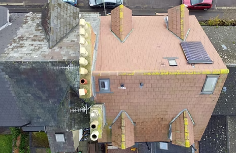
Drone roof inspections - Domestic & small commercial
Effective & Affordable domestic & small commercial drone roof inspections for homeowners & landlords from from terraced houses to listed building.

Large & survey-grade drone roof inspections & surveys
Large surveyor-grade photographic / data surveys, photogrammetry, orthomoosaics,
2D maps & 3D models of land & buildings
Cost Saving
Typically 1/3 of the cost of traditional / mechanical access methods ie cherry pickers, scissor lifts, elevated platforms
Faster & less intrusive
Usually in flight for 20 mins, no installation or mechanical footprint as with traditional access - process is minutes not days
Easier to access & use
View the images at any time from the safety & convenience of your desk or the comfort of your sofa
Reduced Risk
Infinitely safer for people (surveyor,, client & public) & less intrusive for delicate structures (Listed Buildings)
Get in touch
A different perspective
3D photogrammetry models are versatile and used across many fields. They provide detailed, realistic 3D representations of objects, spaces, or structures, derived from photographs, and can be used for documentation, analysis, design, and visualisation purposes
Above the Ground, Beyond the Ordinary
Dive into stories, updates, and use-cases from the world of drone services.
-
We’ve updated our ‘Want to see what an area looks like at 100, 200, 300 & 400 feet by dr
We've been asked by a couple of our clients about the 50 metre minimum we must fly
-
Drone Safety – people & aircraft
This is the kind of damage that can be inflicted on drone pilots who misjudge their aircraft's
-
New CSCS (health, safety & environment) accreditation for construction
For our construction clients we also able to offer pilots with a CSCS Health & Safety &


